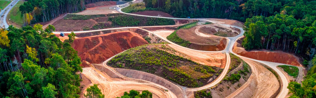
Natural slopes on Cherokee County residential and rural properties influence which portions of the acreage are practical for each intended use through the specific mechanisms that slope creates as the terrain condition that each use type is more or less compatible with depending on the slope’s magnitude and direction relative to the use’s specific terrain requirements. Parking requires the relatively level or gently sloped surface that vehicle stability and comfortable pedestrian movement between the vehicle and the destination demands without the significant grade that makes level vehicle parking and comfortable pedestrian navigation across the grade difficult. Building requires the level or gently sloped building pad that structural performance demands from the foundation’s bearing conditions and the drainage grades that foundation perimeter moisture management requires. Recreation requires the terrain that each recreational activity specifically accommodates, from the level surface that outdoor furniture placement and children’s play equipment needs to the sloped terrain that trail walking, ATV riding, and wildlife hunting specifically use rather than avoid. Access requires the grades that safe vehicle and equipment navigation demands from the routes that serve the property’s interior areas, with grades that fall within the safe operating limits of the vehicles and equipment the routes serve rather than the steeper grades that exceed those limits. For property owners across Ball Ground, Canton, Cherokee County, and North Georgia managing residential and rural properties where the existing terrain’s natural slopes specifically influence which acreage portions are practically suited for each use, understanding how terrain influences each use type and how working with the land’s natural elevation most efficiently organizes the property’s improvement program gives the practical terrain awareness that improvement planning most specifically benefits from before the earthwork commitment that working with or against the terrain creates as the cost difference between the approach that works with what the terrain naturally provides and the approach that imposes what the terrain naturally resists.
How Natural Slopes Influence Parking Area Locations
Parking area locations on Cherokee County residential properties are influenced by the existing terrain’s slope conditions through the specific mechanisms that slope creates as the terrain challenge that parking design must address at every slope condition the parking area occupies rather than only the dramatic slopes that obviously prevent vehicle parking without earthwork modification.
Slopes in the range of two to five percent, which represent the gentle grades that appear nearly level from casual observation, are the most parking-favorable terrain slope conditions because they provide the positive drainage that keeps the parking surface dry without the vehicle instability and pedestrian navigation discomfort that steeper grades create. Slopes in the five to ten percent range begin creating the vehicle stability concerns that cars and trucks parked across the grade rather than aligned with it experience as the tendency to drift that the transverse grade creates against the parked vehicle’s wheel chocks and parking brakes, and the pedestrian navigation discomfort that moving across a perceptible grade toward the vehicle creates relative to the level surface that the gentle slope approximates. Slopes above ten percent make parking design significantly more challenging because the grade within this range exceeds the comfortable threshold for both vehicle stability and pedestrian navigation across the slope direction that the parking stalls must occupy relative to the slope when the terrain at the parking location presents grades in this range.
Working with the terrain’s natural elevation for parking area location means identifying the portions of the acreage where the existing terrain presents the two to five percent slope range that the parking design can work with through the grading that refines the existing gentle slope to the consistent positive drainage grade that parking design requires without the significant cut-and-fill earthwork that the steeper slope portions would require for the level or gently sloped parking condition. The gentle slope portion that parking location naturally works with requires the finish grading that establishes the consistent drainage grade across the parking area rather than the rough grading that reshapes the terrain significantly, a distinction that translates directly into the earthwork scope and cost difference between the terrain-compatible parking location that works with the existing gentle slope and the terrain-resistant parking location that works against the existing steeper slope at the earthwork required to convert it to the parking-appropriate condition.
How Natural Slopes Influence Building Site Locations
Building site locations on Cherokee County residential and rural properties are influenced by the existing terrain’s slope conditions through the specific earthwork, drainage, and foundation performance mechanisms that each slope condition at the candidate building site creates as the site preparation requirements the building development must address before construction can proceed on the prepared building pad that the slope condition at the selected site specifically determines the scope of.
Earthwork Scope as a Function of Existing Slope
The earthwork scope that creating the level building pad from the existing slope requires is directly proportional to the elevation differential across the proposed building pad’s footprint at the candidate building site, with greater elevation differentials requiring more earthwork volume to create the level pad from the existing sloped terrain and lesser differentials requiring less earthwork volume for the equivalent pad creation. The interior terrain walk that physically traverses the candidate building site from its highest corner to its lowest corner at the ground surface level, noting the elevation change at each section of the traverse, reveals the actual elevation differential at the ground surface that the earthwork must address rather than the apparent differential that accessible perimeter observation systematically underestimates on Cherokee County’s wooded terrain where the canopy above the slope appears substantially flatter than the ground beneath it. The candidate building site that the interior terrain walk reveals as presenting a four-foot elevation differential across the proposed pad footprint requires substantially less earthwork to create the level building pad than the candidate that the same walk reveals as presenting a twelve-foot differential across the equivalent footprint, making the terrain walk’s differential revelation the most important single site selection input for the grading and excavation scope and cost that the building development’s earthwork requires from the building site selection that the terrain walk’s differential comparison informs.
Drainage Orientation as a Function of Terrain Position
The terrain position that the candidate building site occupies relative to the surrounding slope determines whether the building site is at an elevated terrain position that naturally drains away from the site in all or most directions, creating the drainage-favorable terrain relationship that requires minimum drainage infrastructure to maintain the foundation perimeter drainage that building performance requires, or at a lower terrain position that receives contributing watershed drainage from the surrounding slopes that drain toward the lower terrain position rather than away from it, creating the drainage-challenging terrain relationship that requires drainage infrastructure to intercept and redirect the contributing watershed drainage before it reaches the foundation perimeter. Working with the terrain’s natural elevation for building site selection means preferring the elevated terrain positions that the slope’s natural drainage orientation makes the most drainage-favorable building sites over the lower terrain positions that the slope’s drainage direction makes the drainage-challenging sites that require more drainage infrastructure for equivalent foundation drainage performance. The post-rain behavioral drainage observation that specifically watches where surface water flows during rain events at each candidate building site reveals the actual watershed drainage relationship that the existing slope creates at each candidate, providing the drainage orientation information that site selection requires from the behavioral observation that the rain event enables rather than the terrain-shape inference that dry-condition assessment substitutes at the lower accuracy that post-rain behavioral observation replaces with the actual drainage direction the slope creates rather than the drainage direction the terrain shape suggests it should create.
How Natural Slopes Influence Recreation Area Locations
Recreation area locations on Cherokee County residential and rural properties are influenced by the existing terrain’s slope conditions in ways that differ fundamentally from the slope influences on parking and building locations because recreational uses span a wide range of slope compatibility from the uses that specifically require level terrain to the uses that specifically prefer or require sloped terrain for the recreational experience that the slope creates as the terrain feature the recreational use depends on rather than the terrain challenge it must overcome.
Level Terrain Requirements for Outdoor Living and Play
Outdoor living areas, children’s play equipment installations, and outdoor entertaining spaces specifically require the level or gently sloped terrain that stable furniture placement, safe play equipment installation, and comfortable outdoor gathering needs from the surface that the outdoor use occupies. The existing terrain portions at Cherokee County residential properties that present the gentle grades within the comfortable outdoor living range are the natural locations for these uses that the terrain specifically supports without the level pad earthwork that locating the outdoor living area on steeper terrain portions would require. Working with the terrain’s natural elevation for outdoor living area placement means identifying the naturally gentle terrain portions and developing them with the finish grading that establishes the comfortable drainage grade rather than imposing the outdoor living area on the steeper terrain portions at the earthwork cost that creating the level or gently sloped outdoor living surface from the steeper existing terrain requires.
Sloped Terrain Advantages for Trail and Hunting Recreation
Trail recreation, hunting, wildlife management, and nature appreciation specifically use and often prefer the sloped terrain that provides the topographic variety, drainage feature diversity, and habitat structure that flat terrain cannot provide at equivalent ecological richness. The natural slopes on Cherokee County rural properties are the terrain that hunting and wildlife management most specifically value as the habitat structure that topographic variation creates for the game movement patterns, feeding areas, and cover conditions that hunting effectiveness specifically requires from the varied terrain. Working with the terrain’s natural elevation for hunting and wildlife recreation means recognizing the sloped wooded sections as the habitat assets that the existing slope makes naturally suited for hunting and wildlife uses rather than the improvement opportunity that earthwork could convert to flat productive area, and allocating the property’s improvement investment toward the clearing, trail development, and food plot creation that works with the existing slope’s habitat value rather than against it through the earthwork that would modify the slope at the expense of the habitat character the slope naturally contributes.
How Natural Slopes Influence Access Route Locations
Access route locations on Cherokee County residential and rural properties are constrained by the existing terrain’s slope conditions through the safe operating gradient limits that the vehicles and equipment the routes serve impose on the grade that the access route can achieve between the road connection and the interior destinations the route serves, with grades within the safe operating limits navigable for the intended traffic and grades above those limits requiring either the route alignment adjustment that finds the lower-grade path through the available terrain or the earthwork modification that reduces the grade at the problematic sections to within the safe operating limit that the traffic requires.
Grade-Following Route Alignment
Working with the terrain’s natural elevation for access route location means finding the route alignment through the available terrain that achieves the consistent grade within the traffic’s safe operating limits by following the terrain’s natural contours rather than crossing the terrain’s contours at the steep grade that the direct path between the road connection and the interior destination would create. The contour-following route that traverses the slope at the gentle consistent grade the terrain’s contours allow the route to maintain produces the grade-safe access that the traffic’s safe operating limit requires from the alignment that works with the terrain rather than the direct alignment that the elevation change over the direct distance creates as the steeper grade that working against the terrain’s elevation produces from the direct path that ignores the contour-following alignment’s grade advantage. Identifying the contour-following route alignment before the access route is committed to the direct steep alignment that the terrain’s elevation change over the direct distance creates requires the site assessment that maps the terrain’s contours between the road connection and the interior destination, identifying the paths through the available terrain that follow the contours at the gentle consistent grade rather than the direct path that the elevation change over the direct distance imposes at the grade that the steeper slope creates between the two connection points at the direct distance.
Slope Base Position Drainage Challenges for Access Routes
Access routes that must cross the slope base positions on Cherokee County’s rolling terrain encounter the chronically wetter soil conditions that the slope base’s drainage collection from the surrounding slopes creates as the wet-season bearing capacity challenge that the Cherokee County clay at slope base positions develops from the elevated moisture that the drainage collection maintains above the bearing capacity failure threshold that the drainage collection advances the slope base clay toward during the wet seasons that the drainage collection adds to the clay’s natural wet-season moisture content. The access route alignment that crosses or follows a slope base position should account for the drainage infrastructure that the slope base’s wet-season bearing capacity challenge requires for the route subgrade moisture management that year-round reliable bearing capacity depends on at slope base positions. Working with the terrain’s natural elevation for access route alignment means specifically identifying the slope base positions that the drainage collection makes the wet-season bearing capacity challenge positions and specifically accounting for those positions in the drainage infrastructure design that the route alignment at those positions requires from the slope-base drainage management that the post-rain behavioral observation at those positions reveals as the actual drainage challenge the route design must address.
Why Working With the Land’s Natural Elevation Matters
Working with the land’s natural elevation for property use location and improvement planning matters through the earthwork cost efficiency, drainage performance, and natural character preservation advantages that the terrain-compatible approach provides relative to the terrain-resistant approach that places uses and improvements at the terrain positions that the existing slope resists rather than supports at the earthwork volume and cost that overcoming the resistance requires.
Earthwork cost efficiency from terrain-compatible placement means that the earthwork required to prepare the terrain-compatible position for the use it naturally supports is the finish grading and minor earthwork that refines the existing terrain toward the use’s requirements rather than the rough grading and major earthwork that reshapes the terrain significantly toward the designed condition the terrain-resistant position requires before the use can proceed on the prepared surface. The difference between the finish grading that the terrain-compatible position requires and the rough grading and major earthwork that the terrain-resistant position requires is the earthwork cost difference that terrain-compatible placement avoids by locating the use where the terrain supports it rather than where it resists it at the earthwork cost that overcoming the resistance imposes on the improvement budget that the cost difference could have directed toward the additional improvements that the terrain-compatible placement’s earthwork savings makes available.
Drainage performance from terrain-compatible placement means that the drainage infrastructure the terrain-compatible position requires for the use’s drainage management is the minimum infrastructure that the terrain’s natural drainage orientation provides as the starting condition that the improvement refines rather than the maximum infrastructure that the terrain-resistant position requires to counteract the drainage challenges that the terrain’s natural drainage orientation creates at the less favorable terrain positions. The elevated terrain position that building development’s drainage performance benefits from presents the natural positive drainage orientation that foundation perimeter drainage design refines with finish grading rather than overcoming with the extensive drainage infrastructure that the lower terrain position’s contributing watershed relationship requires to manage the watershed drainage that the lower terrain position receives from the surrounding slopes rather than sheds from the elevated position’s natural drainage orientation.
Natural character preservation from terrain-compatible placement means that the improvements placed at the terrain positions that naturally support them preserve the natural terrain character at the positions that natural support does not require the improvements to occupy rather than reshaping the full acreage’s terrain toward the designed conditions that each use requires regardless of the natural terrain character that the terrain-resistant positions contain as the characteristic that the earthwork modification eliminates in the process of creating the designed condition from the existing terrain that naturally provides the character the earthwork removes.
Evaluating Your Property’s Terrain for Use-Compatible Location Selection
Evaluating the existing terrain for use-compatible location selection requires the systematic terrain assessment that characterizes each portion of the acreage by the slope condition it presents and compares those slope conditions to the slope requirements that each intended use creates as the terrain compatibility criteria that terrain-compatible location selection applies to the terrain assessment findings for each acreage portion.
The terrain assessment begins with the systematic property walk that traverses the full acreage at intervals that allow the terrain’s character to be specifically observed at each portion of the property rather than only at the accessible perimeter positions that accessible observation provides without the interior terrain access that the systematic property walk achieves by specifically entering the interior terrain portions. The interior terrain observations at each acreage portion note the slope magnitude, slope direction, terrain position relative to the surrounding higher and lower terrain, and the specific terrain features including rock outcrops, drainage channels, and terrain irregularities that each portion presents as the characteristics that the use-compatibility assessment uses to evaluate each portion’s suitability for each intended use. Comparing these interior terrain observations to the slope compatibility criteria that each intended use creates as the terrain requirement that the use specifically needs from the terrain it occupies identifies the acreage portions where the existing terrain most specifically supports each use through the terrain compatibility that the interior observation’s slope magnitude, drainage orientation, and terrain position assessment reveals as the matching or mismatching condition between the existing terrain and the use’s terrain requirements.
Frequently Asked Questions
How do I determine whether a slope on my property can be used as-is or needs grading modification for a specific intended use?
Determining whether a slope can be used as-is or needs grading modification for a specific intended use requires comparing the existing slope’s magnitude and direction to the slope requirements that the specific intended use creates as the terrain condition it needs from the surface it occupies. The comparison that specifically reveals whether the existing slope is within the use’s acceptable range or outside it at the earthwork that grading modification would require to bring it within range is most practically conducted by visiting the slope at the specific use’s activity timing and specifically attempting to conduct the intended activity on the existing slope at the actual conditions the slope presents. Attempting to park a vehicle on the existing slope reveals immediately whether the parking experience on the existing grade is within the comfortable range or is already creating the instability and navigation discomfort that indicates the grade exceeds the comfortable parking range. Attempting to place outdoor furniture on the existing slope reveals whether the furniture stability the outdoor living use requires is achievable on the existing grade or whether the furniture placement instability the existing grade creates indicates the grade modification the outdoor living use requires. This direct use-attempt evaluation at each slope’s actual conditions provides the most reliable slope-to-use compatibility assessment available from the actual use experience on the actual slope rather than the grade percentage comparison that would require the measurement equipment that the direct use-attempt evaluation substitutes for the measurement with the practical experience of attempting the use on the slope at the conditions that reveal immediately whether the slope is within the compatible range for that use or requires the grading modification that the incompatible experience indicates as the necessary preparation.
Can multiple uses be organized across different slope portions of the same property to maximize terrain compatibility for each use?
Multiple uses can be specifically organized across different slope portions of the same property to maximize terrain compatibility for each use by allocating each use to the slope portions where the terrain conditions most specifically support that use’s requirements rather than the uniform distribution of all uses across the full acreage without the slope-to-use compatibility matching that terrain-organized use allocation specifically achieves. The gentle slope portions that parking and outdoor living require from the terrain are naturally the building site candidates and the parking area candidates that the terrain-compatible allocation directs to those portions. The steeper wooded slope portions that hunting and wildlife management benefit from as the habitat structure that topographic variation provides are the hunting and wildlife allocation candidates that the terrain-compatible allocation directs those uses toward rather than attempting to impose the building and parking uses on those portions at the earthwork cost that those uses’ terrain requirements would impose on the steeper slope portions that the hunting and wildlife uses specifically value as habitat without the earthwork. The level valley portions and stream-adjacent positions that certain agricultural uses and pond development value are the candidates that the terrain-compatible allocation directs those uses toward rather than imposing those uses on the elevated slope portions that naturally drain toward rather than collecting the water resources those uses specifically require. This terrain-organized use allocation produces the improvement program that places each use at the acreage portion where the terrain most specifically supports it, minimizing the total earthwork required across the full improvement program by avoiding the terrain-resistant placement that each use’s terrain requirements impose on the portions that resist rather than support those requirements.
How does clearing vegetation from sloped portions of the property change the terrain assessment for intended uses?
Clearing vegetation from sloped property portions changes the terrain assessment for intended uses primarily by revealing the actual ground-level terrain conditions that the vegetation was concealing from the accessible observation that the clearing makes accessible for the first time since the vegetation grew tall enough to prevent interior terrain access at the ground level that the clearing now specifically restores. The terrain assessment that was conducted on the vegetated slope portions before clearing necessarily proceeded from the accessible perimeter observation that systematically underestimates the actual elevation differential and terrain character at the interior ground surface that the vegetation prevented from being reached at the assessment accuracy the interior access provides. After clearing, the revealed terrain at the interior positions allows the terrain assessment to be updated from the accessible perimeter estimates that pre-clearing assessment produced to the actual interior terrain observations that the cleared access enables. This post-clearing terrain assessment update commonly reveals the building site that the pre-clearing assessment’s differential underestimate had not identified as the earthwork-intensive site it actually is, the drainage channel that the pre-clearing assessment had not identified as the potential regulated watercourse whose buffer zone the building site should specifically avoid, and the rock outcrop that the pre-clearing assessment had not identified as the terrain feature that the building site’s foundation preparation must specifically address. The post-clearing terrain assessment update that the cleared access specifically enables is the assessment that most accurately informs the building site selection, access route alignment, and use organization that the improvement program should be based on rather than the pre-clearing accessible perimeter estimates that the clearing specifically replaces with the interior terrain accuracy the clearing access provides.
What are the most common terrain compatibility mistakes that North Georgia property owners make when planning improvements on sloped land?
The most common terrain compatibility mistake that North Georgia property owners make when planning improvements on sloped land is selecting building site, parking, and outdoor living locations from the accessible perimeter’s apparent terrain conditions rather than the interior terrain walk’s actual ground-level conditions, producing the location selections that the apparent terrain at the perimeter suggested as the compatible locations at the apparent slope conditions the perimeter observation characterized without the actual interior ground-level conditions that the interior terrain walk would have revealed as different from the apparent at the accuracy that reveals the actual slope, the actual elevation differential, and the actual drainage orientation that the actual interior conditions present rather than the apparently favorable conditions the accessible perimeter observation systematically substitutes for the actual interior conditions on Cherokee County’s wooded terrain where the canopy above the slope appears flatter than the ground beneath it. This single mistake of selecting locations from apparent perimeter conditions rather than actual interior terrain walk conditions produces the building site earthwork cost overrun when the actual interior differential reveals the scope the apparent differential underestimated, the drainage challenge when the actual post-rain watershed observation reveals the contributing drainage the apparent dry-condition assessment didn’t reveal, and the equipment operation safety concern when the actual interior slope gradient reveals the steeper actual gradient that the apparent perimeter gradient underestimated as the safe operating threshold the equipment actually encounters in the interior rather than the gentler apparent gradient the accessible perimeter suggested as the actual interior condition without the interior walk that reveals the actual gradient the improvement’s execution will encounter.
Ready to Evaluate Your Property’s Natural Slopes for Improvement Planning?
The natural slopes on Cherokee County residential and rural properties that influence which acreage portions are most practically suited for parking, buildings, recreation, and access are the terrain conditions that terrain-compatible improvement planning most specifically works with to allocate each intended use to the acreage portion where the existing terrain most specifically supports that use’s requirements, minimizing the total earthwork that terrain-resistant placement would impose on the improvement program by locating each use at the portions the terrain naturally accommodates rather than the portions the terrain naturally resists at the earthwork cost that overcoming the resistance requires. The systematic terrain assessment that walks the full acreage at interior positions to characterize each portion’s actual slope conditions at the ground level accuracy that accessible perimeter observation cannot provide, the post-rain drainage behavioral observation that reveals the actual watershed relationships the existing slope creates at each candidate use location, and the slope-to-use compatibility matching that compares the actual terrain conditions to each use’s terrain requirements together produce the terrain-aware improvement program that works with the land’s natural elevation rather than against it at the earthwork cost that terrain-resistant improvement planning imposes on the improvement budget that terrain-compatible planning more efficiently directs toward the uses that the terrain naturally supports.
Bardin Outdoors works with property owners across Ball Ground, Canton, Cherokee County, and North Georgia on grading and excavation, clearing, and forestry mulching improvements planned from the terrain-compatible location selection that the interior terrain walk, post-rain drainage observation, and slope-to-use compatibility assessment together produce as the terrain-aware planning basis that most efficiently allocates each improvement to the acreage portion where the natural elevation most specifically supports it. To learn more about how Bardin Outdoors can help plan terrain-compatible improvements on your North Georgia property, contact us.